
SEATTLE — Puget Sound Extended Forecast
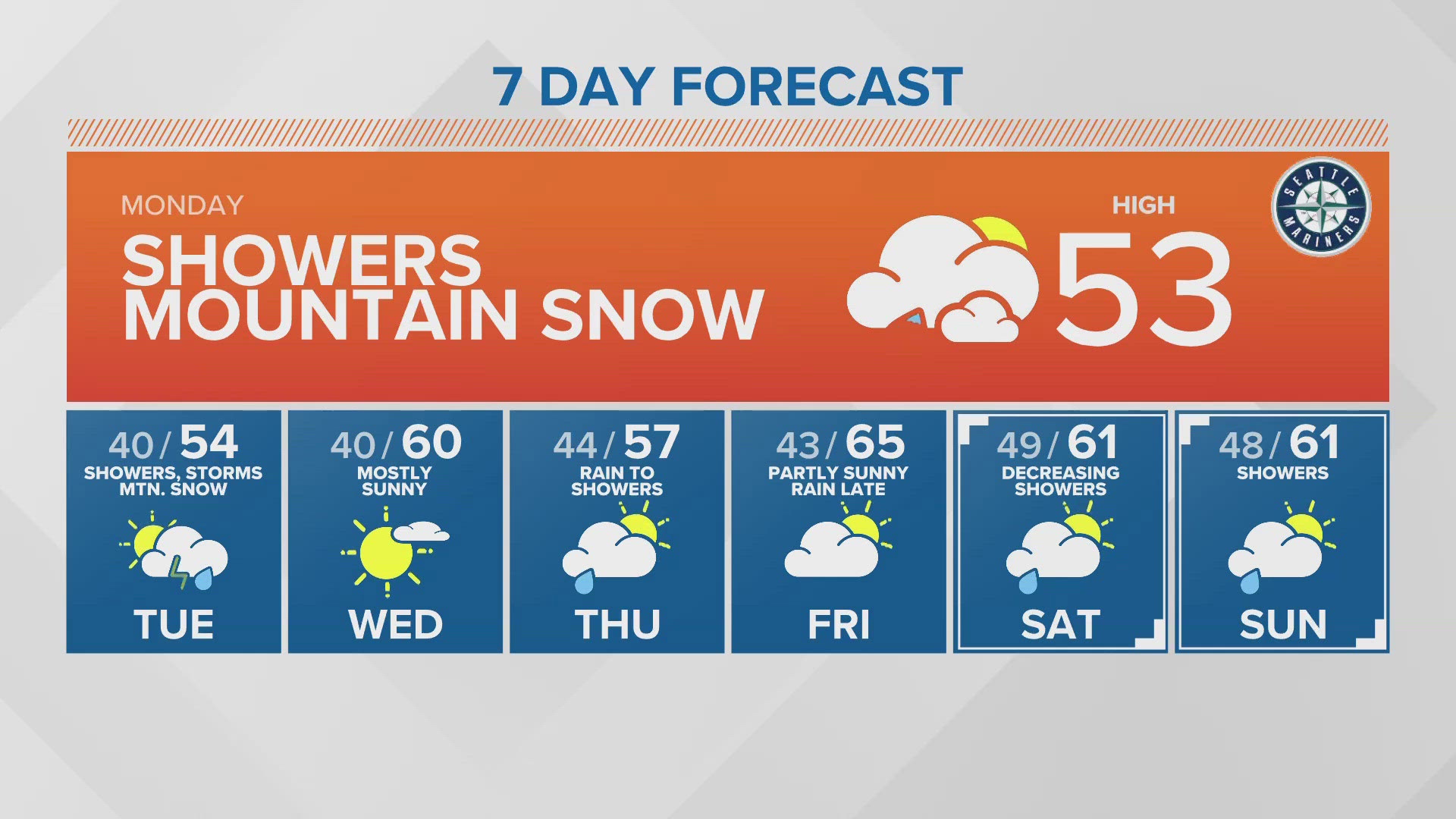
Monday: Decreasing showers this morning with gradual clearing. Showers mainly in the central Sound this afternoon otherwise partly sunny. High temperatures in the low to mid-50s. 2-6 inches of new snow today above 3,500 feet.
Tuesday: Showers mainly south Sound gradually dropping southward with clearing from the north during the day. Slight chance of a thunderstorm in afternoon Olympia southward. becoming partly sunny during the afternoon. Morning lows around 40 degrees. High temperatures in the mid-50s.
Wednesday: Mostly sunny and warmer. Morning lows around 40 degrees. Highs in the upper 50s to lower 60s.
Thursday: Steady rain early changing to showers during the morning - decreasing in the afternoon. Morning lows in the low to mid-40s. Highs in the mid to upper 50s.
Friday: Partly sunny with increasing rain later in the day. Morning lows in low to mid-40s. Highs in the mid-60s.
Saturday: Decreasing showers with afternoon sunbreaks. Morning lows in the mid to upper 40s. High temperature in the low to mid-60s.
Sunday: Partly sunny with slight chance of a shower. Morning lows in the mid 40s. Highs in the low to mid 60s.
Discussion:
While April is ending a little on the wet and cool side, overall it has been a dry month. Sea-Tac has only had 0.64" leaving the airport 2.26" below normal. Other stations are below normal as well but not quite as dry as Sea=Tac.
Cooler air has lowered snow levels down to around 2,500 feet this morning. Overnight 2-3" accumulated above 3,000 feet and another 2-6" is possible during the day today mainly above 3,500 feet.
A weak upper level system is swinging through western Washington today producing some convergence, focusing most of the rainfall in the central Sound today with clearing to the north of Everett and to the south of Tacoma. There is a vry slight chance of an isolated thunderstorm this afternoon in the central Sound.
Another upper level disturbance moves through later tonight and early Tuesday morning for another round of showers mainly south of Seattle Showers. the showers will gradually drop farther south in the afternoon with a slight chance of a thunderstorm mainly Olympia southward in afternoon.
A small area of high pressure will move through the State on Wednesday for a mostly sunny day with highs pushing up to near 60 degrees - close to the normal highs which are in the low 60s.
A more organized system moves in later Wednesday night with steady rain to start Thursday but it will turn to off and on showers during the morning - decreasing in the afternoon. Showers will end overnight Thursday into Friday.
High pressure will zip through during the day on Friday with highs warming into the mid 60s. However, a warm front spreads steady rain in Friday night for a mild but wet start to the weekend. Saturday morning will start wet early but change to off and on showers during the morning and those should end later Saturday.
An area of high pressure builds in later Saturday and moves through Sunday for a partly sunny day but rain may return Sunday night. It will be mild over the weekend with highs staying in the low to mid 60s.